|
|
|||||||||||||||||
| Point ID: 5105 | Downloads | Plots | Site Data | Code: 03CB004 |
|
|
|||||||||||||||||
| Download | |
|---|---|
| Site Descriptor Information | Site Time Series Data |
| Link to all available data | |
| View: | Time Series | All |
| Units: | m3/s |
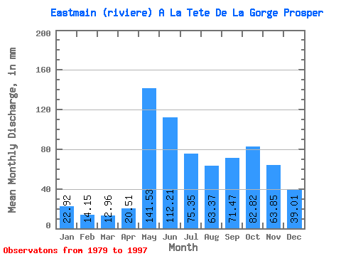
| Statistic | Jan | Feb | Mar | Apr | May | Jun | Jul | Aug | Sep | Oct | Nov | Dec | Annual |
|---|---|---|---|---|---|---|---|---|---|---|---|---|---|
| Mean | 22.91 | 14.27 | 12.96 | 20.51 | 141.51 | 112.21 | 75.33 | 63.36 | 71.47 | 82.81 | 63.85 | 39.01 | 724.71 |
| Standard Deviation | 4.20 | 2.27 | 4.01 | 15.11 | 26.16 | 28.29 | 26.61 | 20.17 | 23.46 | 15.97 | 17.01 | 9.43 | 76.12 |
| Min | 15.64 | 9.20 | 7.16 | 8.66 | 93.98 | 67.71 | 35.91 | 25.65 | 33.31 | 49.30 | 44.21 | 26.53 | 588.57 |
| Max | 29.41 | 17.67 | 26.66 | 71.34 | 198.97 | 184.10 | 155.17 | 90.10 | 123.54 | 116.88 | 110.95 | 55.06 | 850.45 |
| Coefficient of Variation | 0.18 | 0.16 | 0.31 | 0.74 | 0.18 | 0.25 | 0.35 | 0.32 | 0.33 | 0.19 | 0.27 | 0.24 | 0.10 |
 Return to R-Arctic Net Home Page