|
|
|||||||||||||||||
| Point ID: 5101 | Downloads | Plots | Site Data | Code: 03CA001 |
|
|
|||||||||||||||||
| Download | |
|---|---|
| Site Descriptor Information | Site Time Series Data |
| Link to all available data | |
| View: | Time Series | All |
| Units: | m3/s |
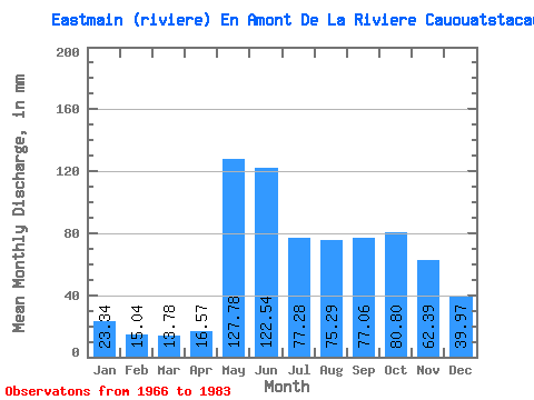
| Statistic | Jan | Feb | Mar | Apr | May | Jun | Jul | Aug | Sep | Oct | Nov | Dec | Annual |
|---|---|---|---|---|---|---|---|---|---|---|---|---|---|
| Mean | 23.34 | 15.17 | 13.78 | 16.57 | 127.76 | 122.54 | 77.27 | 75.28 | 77.06 | 80.79 | 62.40 | 39.97 | 721.63 |
| Standard Deviation | 4.67 | 3.61 | 4.38 | 8.86 | 38.77 | 37.13 | 30.38 | 33.69 | 27.07 | 25.56 | 16.95 | 8.22 | 86.08 |
| Min | 15.21 | 9.93 | 8.43 | 8.67 | 59.10 | 61.23 | 36.48 | 35.32 | 40.00 | 45.25 | 37.09 | 25.39 | 574.70 |
| Max | 33.48 | 22.51 | 25.63 | 45.36 | 189.08 | 211.38 | 149.37 | 145.21 | 143.90 | 144.98 | 93.85 | 52.87 | 848.22 |
| Coefficient of Variation | 0.20 | 0.24 | 0.32 | 0.53 | 0.30 | 0.30 | 0.39 | 0.45 | 0.35 | 0.32 | 0.27 | 0.21 | 0.12 |
 Return to R-Arctic Net Home Page