|
|
|||||||||||||||||
| Point ID: 5100 | Downloads | Plots | Site Data | Code: 03BF001 |
|
|
|||||||||||||||||
| Download | |
|---|---|
| Site Descriptor Information | Site Time Series Data |
| Link to all available data | |
| View: | Time Series | All |
| Units: | m3/s |
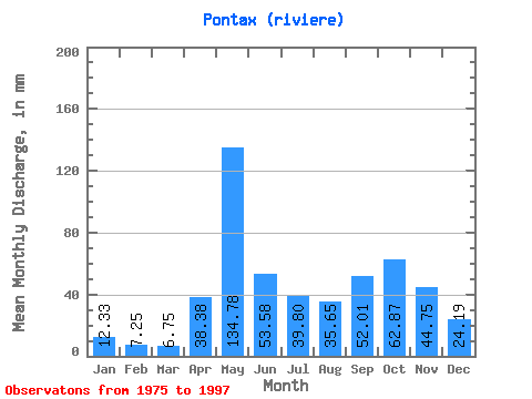
| Statistic | Jan | Feb | Mar | Apr | May | Jun | Jul | Aug | Sep | Oct | Nov | Dec | Annual |
|---|---|---|---|---|---|---|---|---|---|---|---|---|---|
| Mean | 12.33 | 7.32 | 6.75 | 38.38 | 134.76 | 53.58 | 39.80 | 35.64 | 52.01 | 62.86 | 44.75 | 24.19 | 513.09 |
| Standard Deviation | 5.00 | 2.11 | 2.56 | 28.27 | 40.20 | 16.81 | 15.72 | 18.80 | 21.54 | 15.78 | 13.07 | 10.04 | 63.10 |
| Min | 6.38 | 3.67 | 3.24 | 3.37 | 51.45 | 16.43 | 24.54 | 8.49 | 17.96 | 36.10 | 20.86 | 12.01 | 419.38 |
| Max | 30.96 | 13.54 | 14.99 | 118.75 | 219.87 | 86.40 | 83.11 | 70.36 | 91.08 | 94.54 | 68.95 | 53.65 | 628.05 |
| Coefficient of Variation | 0.41 | 0.29 | 0.38 | 0.74 | 0.30 | 0.31 | 0.40 | 0.53 | 0.41 | 0.25 | 0.29 | 0.41 | 0.12 |
 Return to R-Arctic Net Home Page