|
|
|||||||||||||||||
| Point ID: 510 | Downloads | Plots | Site Data | Code: 05EC007 |
|
|
|||||||||||||||||
| Download | |
|---|---|
| Site Descriptor Information | Site Time Series Data |
| Link to all available data | |
| View: | Time Series | All |
| Units: | m3/s |
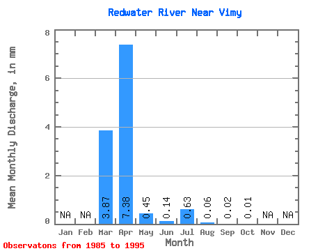
| Statistic | Jan | Feb | Mar | Apr | May | Jun | Jul | Aug | Sep | Oct | Nov | Dec | Annual |
|---|---|---|---|---|---|---|---|---|---|---|---|---|---|
| Mean | 3.87 | 7.38 | 0.45 | 0.14 | 0.64 | 0.06 | 0.02 | 0.01 | |||||
| Standard Deviation | 6.68 | 10.11 | 0.74 | 0.21 | 1.13 | 0.12 | 0.04 | 0.03 | |||||
| Min | 0.00 | 0.01 | 0.00 | 0.00 | 0.00 | 0.00 | 0.00 | 0.00 | |||||
| Max | 21.64 | 31.45 | 2.53 | 0.62 | 3.64 | 0.36 | 0.13 | 0.10 | |||||
| Coefficient of Variation | 1.73 | 1.37 | 1.64 | 1.54 | 1.77 | 2.07 | 2.42 | 2.67 |
 Return to R-Arctic Net Home Page