|
|
|||||||||||||||||
| Point ID: 5099 | Downloads | Plots | Site Data | Code: 03BE001 |
|
|
|||||||||||||||||
| Download | |
|---|---|
| Site Descriptor Information | Site Time Series Data |
| Link to all available data | |
| View: | Time Series | All |
| Units: | m3/s |
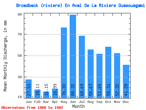
| Statistic | Jan | Feb | Mar | Apr | May | Jun | Jul | Aug | Sep | Oct | Nov | Dec | Annual |
|---|---|---|---|---|---|---|---|---|---|---|---|---|---|
| Mean | 27.50 | 18.27 | 16.15 | 18.99 | 76.29 | 88.32 | 68.68 | 55.66 | 51.65 | 58.30 | 52.32 | 41.27 | 576.81 |
| Standard Deviation | 5.30 | 3.26 | 2.74 | 6.52 | 24.34 | 27.89 | 18.60 | 14.72 | 19.56 | 22.70 | 16.72 | 12.77 | 126.25 |
| Min | 20.36 | 13.46 | 12.17 | 11.73 | 33.51 | 46.38 | 37.74 | 28.66 | 24.86 | 19.26 | 16.67 | 24.59 | 332.13 |
| Max | 37.27 | 24.97 | 23.80 | 32.74 | 128.42 | 159.16 | 112.76 | 85.67 | 97.92 | 108.06 | 86.70 | 80.34 | 808.07 |
| Coefficient of Variation | 0.19 | 0.18 | 0.17 | 0.34 | 0.32 | 0.32 | 0.27 | 0.27 | 0.38 | 0.39 | 0.32 | 0.31 | 0.22 |
 Return to R-Arctic Net Home Page