|
|
|||||||||||||||||
| Point ID: 5088 | Downloads | Plots | Site Data | Code: 03AC008 |
|
|
|||||||||||||||||
| Download | |
|---|---|
| Site Descriptor Information | Site Time Series Data |
| Link to all available data | |
| View: | Time Series | All |
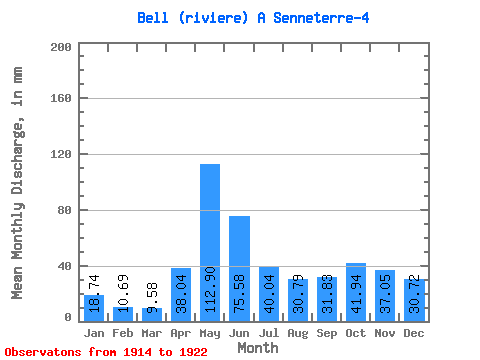
| Units: | m3/s |
| Statistic | Jan | Feb | Mar | Apr | May | Jun | Jul | Aug | Sep | Oct | Nov | Dec | Annual |
|---|---|---|---|---|---|---|---|---|---|---|---|---|---|
| Mean | 18.74 | 10.78 | 9.57 | 38.03 | 112.89 | 75.58 | 40.03 | 30.79 | 31.83 | 41.93 | 37.05 | 30.71 | 487.49 |
| Standard Deviation | 4.90 | 3.40 | 2.90 | 17.16 | 23.40 | 25.60 | 22.12 | 19.09 | 14.81 | 27.08 | 13.82 | 9.15 | 91.49 |
| Min | 11.69 | 7.17 | 7.13 | 20.15 | 90.75 | 39.80 | 13.45 | 16.12 | 14.13 | 7.25 | 12.41 | 15.61 | 381.08 |
| Max | 25.13 | 17.11 | 15.48 | 71.86 | 144.69 | 107.24 | 81.36 | 70.57 | 49.88 | 88.21 | 54.17 | 45.95 | 608.14 |
| Coefficient of Variation | 0.26 | 0.32 | 0.30 | 0.45 | 0.21 | 0.34 | 0.55 | 0.62 | 0.47 | 0.65 | 0.37 | 0.30 | 0.19 |
 Return to R-Arctic Net Home Page