|
|
|||||||||||||||||
| Point ID: 5087 | Downloads | Plots | Site Data | Code: 03AC007 |
|
|
|||||||||||||||||
| Download | |
|---|---|
| Site Descriptor Information | Site Time Series Data |
| Link to all available data | |
| View: | Time Series | All |
| Units: | m3/s |
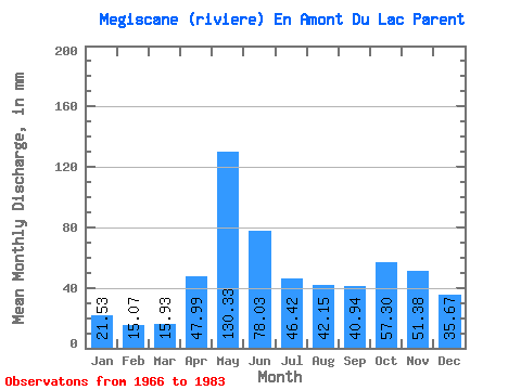
| Statistic | Jan | Feb | Mar | Apr | May | Jun | Jul | Aug | Sep | Oct | Nov | Dec | Annual |
|---|---|---|---|---|---|---|---|---|---|---|---|---|---|
| Mean | 21.53 | 15.20 | 15.93 | 47.99 | 130.31 | 78.03 | 46.41 | 42.14 | 40.94 | 57.29 | 51.38 | 35.67 | 581.75 |
| Standard Deviation | 5.56 | 2.31 | 4.69 | 31.54 | 32.62 | 35.05 | 12.48 | 19.05 | 14.47 | 16.75 | 21.54 | 14.13 | 110.07 |
| Min | 15.08 | 11.39 | 11.05 | 15.38 | 80.24 | 33.38 | 30.68 | 16.92 | 17.65 | 32.87 | 28.85 | 19.92 | 419.91 |
| Max | 33.84 | 19.20 | 32.55 | 122.27 | 224.94 | 185.90 | 71.22 | 94.75 | 67.06 | 88.94 | 104.18 | 74.12 | 832.74 |
| Coefficient of Variation | 0.26 | 0.15 | 0.29 | 0.66 | 0.25 | 0.45 | 0.27 | 0.45 | 0.35 | 0.29 | 0.42 | 0.40 | 0.19 |
 Return to R-Arctic Net Home Page