|
|
|||||||||||||||||
| Point ID: 5085 | Downloads | Plots | Site Data | Code: 03AC005 |
|
|
|||||||||||||||||
| Download | |
|---|---|
| Site Descriptor Information | Site Time Series Data |
| Link to all available data | |
| View: | Time Series | All |
| Units: | m3/s |
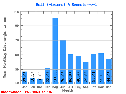
| Statistic | Jan | Feb | Mar | Apr | May | Jun | Jul | Aug | Sep | Oct | Nov | Dec | Annual |
|---|---|---|---|---|---|---|---|---|---|---|---|---|---|
| Mean | 27.02 | 18.39 | 16.82 | 32.45 | 100.81 | 70.03 | 50.58 | 48.43 | 39.82 | 51.41 | 52.05 | 44.06 | 553.26 |
| Standard Deviation | 8.05 | 3.69 | 1.82 | 15.33 | 23.11 | 11.18 | 11.87 | 15.55 | 17.94 | 18.39 | 19.08 | 20.11 | 81.97 |
| Min | 18.98 | 13.24 | 14.27 | 14.98 | 74.69 | 45.20 | 35.39 | 27.86 | 19.02 | 32.30 | 27.35 | 22.07 | 434.15 |
| Max | 45.49 | 26.61 | 20.45 | 62.13 | 152.07 | 82.45 | 71.86 | 74.02 | 78.15 | 93.66 | 85.31 | 83.84 | 654.33 |
| Coefficient of Variation | 0.30 | 0.20 | 0.11 | 0.47 | 0.23 | 0.16 | 0.23 | 0.32 | 0.45 | 0.36 | 0.37 | 0.46 | 0.15 |
 Return to R-Arctic Net Home Page