|
|
|||||||||||||||||
| Point ID: 5081 | Downloads | Plots | Site Data | Code: 03AB003 |
|
|
|||||||||||||||||
| Download | |
|---|---|
| Site Descriptor Information | Site Time Series Data |
| Link to all available data | |
| View: | Time Series | All |
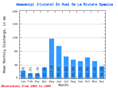
| Units: | m3/s |
| Statistic | Jan | Feb | Mar | Apr | May | Jun | Jul | Aug | Sep | Oct | Nov | Dec | Annual |
|---|---|---|---|---|---|---|---|---|---|---|---|---|---|
| Mean | 23.08 | 15.64 | 15.16 | 32.90 | 117.38 | 95.65 | 64.87 | 55.38 | 51.28 | 61.95 | 51.30 | 36.38 | 626.52 |
| Standard Deviation | 5.38 | 2.78 | 4.14 | 25.74 | 25.80 | 29.88 | 17.87 | 17.32 | 14.87 | 18.49 | 18.63 | 12.70 | 95.68 |
| Min | 13.06 | 10.99 | 11.47 | 10.76 | 73.18 | 44.35 | 43.25 | 24.63 | 27.72 | 24.20 | 26.34 | 19.48 | 444.13 |
| Max | 37.81 | 21.01 | 30.22 | 122.53 | 170.42 | 185.74 | 103.25 | 81.34 | 70.69 | 99.67 | 93.84 | 72.03 | 831.05 |
| Coefficient of Variation | 0.23 | 0.18 | 0.27 | 0.78 | 0.22 | 0.31 | 0.28 | 0.31 | 0.29 | 0.30 | 0.36 | 0.35 | 0.15 |
 Return to R-Arctic Net Home Page