|
|
|||||||||||||||||
| Point ID: 494 | Downloads | Plots | Site Data | Code: 05EA009 |
|
|
|||||||||||||||||
| Download | |
|---|---|
| Site Descriptor Information | Site Time Series Data |
| Link to all available data | |
| View: | Time Series | All |
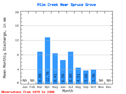
| Units: | m3/s |
| Statistic | Jan | Feb | Mar | Apr | May | Jun | Jul | Aug | Sep | Oct | Nov | Dec | Annual |
|---|---|---|---|---|---|---|---|---|---|---|---|---|---|
| Mean | 2.59 | 3.73 | 2.45 | 1.92 | 2.58 | 1.32 | 1.07 | 1.16 | |||||
| Standard Deviation | 2.05 | 1.85 | 1.25 | 1.04 | 2.21 | 0.73 | 0.45 | 0.39 | |||||
| Min | 0.46 | 1.23 | 0.91 | 0.10 | 0.03 | 0.01 | 0.34 | 0.56 | |||||
| Max | 5.99 | 6.96 | 5.43 | 4.48 | 9.18 | 2.65 | 2.46 | 2.02 | |||||
| Coefficient of Variation | 0.79 | 0.50 | 0.51 | 0.54 | 0.85 | 0.55 | 0.42 | 0.34 |
 Return to R-Arctic Net Home Page