|
|
|||||||||||||||||
| Point ID: 483 | Downloads | Plots | Site Data | Code: 05DF001 |
|
|
|||||||||||||||||
| Download | |
|---|---|
| Site Descriptor Information | Site Time Series Data |
| Link to all available data | |
| View: | Time Series | All |
| Units: | m3/s |
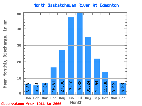
| Statistic | Jan | Feb | Mar | Apr | May | Jun | Jul | Aug | Sep | Oct | Nov | Dec | Annual |
|---|---|---|---|---|---|---|---|---|---|---|---|---|---|
| Mean | 6.22 | 5.63 | 7.06 | 16.19 | 26.40 | 45.92 | 48.62 | 34.35 | 21.39 | 13.51 | 8.31 | 6.70 | 238.79 |
| Standard Deviation | 3.55 | 3.47 | 4.50 | 7.49 | 13.28 | 20.65 | 19.78 | 14.10 | 9.44 | 4.21 | 3.41 | 3.85 | 53.27 |
| Min | 1.60 | 1.43 | 2.35 | 5.45 | 9.24 | 17.40 | 13.20 | 12.82 | 10.00 | 7.47 | 3.52 | 1.88 | 157.83 |
| Max | 15.30 | 13.33 | 18.36 | 39.99 | 108.08 | 100.90 | 115.73 | 82.64 | 71.65 | 28.12 | 17.40 | 18.36 | 407.89 |
| Coefficient of Variation | 0.57 | 0.62 | 0.64 | 0.46 | 0.50 | 0.45 | 0.41 | 0.41 | 0.44 | 0.31 | 0.41 | 0.57 | 0.22 |
 Return to R-Arctic Net Home Page