|
|
|||||||||||||||||
| Point ID: 477 | Downloads | Plots | Site Data | Code: 05DE001 |
|
|
|||||||||||||||||
| Download | |
|---|---|
| Site Descriptor Information | Site Time Series Data |
| Link to all available data | |
| View: | Time Series | All |
| Units: | m3/s |
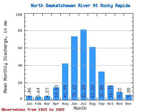
| Statistic | Jan | Feb | Mar | Apr | May | Jun | Jul | Aug | Sep | Oct | Nov | Dec | Annual |
|---|---|---|---|---|---|---|---|---|---|---|---|---|---|
| Mean | 4.86 | 3.67 | 4.57 | 14.63 | 41.98 | 73.12 | 81.17 | 61.19 | 32.85 | 16.74 | 9.22 | 5.88 | 371.26 |
| Standard Deviation | 1.49 | 0.53 | 1.26 | 4.67 | 24.80 | 32.94 | 35.34 | 13.34 | 10.84 | 4.85 | 3.58 | 2.02 | 93.31 |
| Min | 3.44 | 2.78 | 2.94 | 6.34 | 21.38 | 37.81 | 49.38 | 41.89 | 16.05 | 11.83 | 5.85 | 3.37 | 245.10 |
| Max | 7.15 | 4.39 | 6.40 | 21.05 | 84.89 | 146.25 | 154.78 | 85.38 | 53.27 | 25.43 | 15.10 | 9.45 | 516.46 |
| Coefficient of Variation | 0.31 | 0.14 | 0.28 | 0.32 | 0.59 | 0.45 | 0.43 | 0.22 | 0.33 | 0.29 | 0.39 | 0.34 | 0.25 |
 Return to R-Arctic Net Home Page