|
|
|||||||||||||||||
| Point ID: 465 | Downloads | Plots | Site Data | Code: 05DC008 |
|
|
|||||||||||||||||
| Download | |
|---|---|
| Site Descriptor Information | Site Time Series Data |
| Link to all available data | |
| View: | Time Series | All |
| Units: | m3/s |
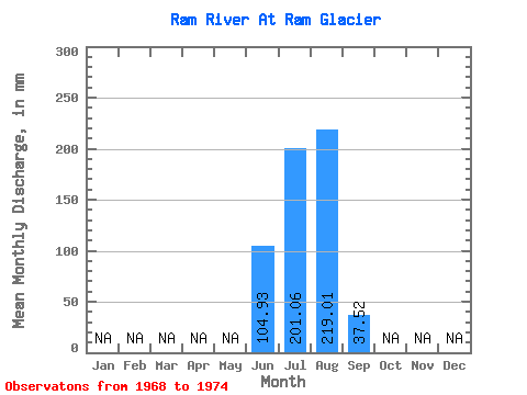
| Statistic | Jan | Feb | Mar | Apr | May | Jun | Jul | Aug | Sep | Oct | Nov | Dec | Annual |
|---|---|---|---|---|---|---|---|---|---|---|---|---|---|
| Mean | 105.16 | 200.67 | 218.88 | 37.87 | |||||||||
| Standard Deviation | 65.97 | 85.92 | 95.86 | 7.71 | |||||||||
| Min | 29.88 | 116.31 | 119.18 | 29.19 | |||||||||
| Max | 152.88 | 366.16 | 348.21 | 47.95 | |||||||||
| Coefficient of Variation | 0.63 | 0.43 | 0.44 | 0.20 |
 Return to R-Arctic Net Home Page