|
|
|||||||||||||||||
| Point ID: 451 | Downloads | Plots | Site Data | Code: 05DB001 |
|
|
|||||||||||||||||
| Download | |
|---|---|
| Site Descriptor Information | Site Time Series Data |
| Link to all available data | |
| View: | Time Series | All |
| Units: | m3/s |
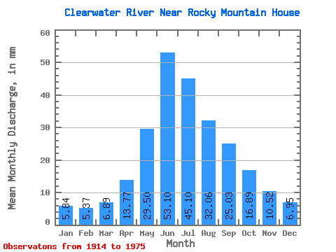
| Statistic | Jan | Feb | Mar | Apr | May | Jun | Jul | Aug | Sep | Oct | Nov | Dec | Annual |
|---|---|---|---|---|---|---|---|---|---|---|---|---|---|
| Mean | 5.82 | 5.40 | 6.87 | 13.73 | 29.41 | 52.93 | 44.96 | 31.96 | 24.95 | 16.84 | 10.49 | 6.93 | 250.69 |
| Standard Deviation | 1.78 | 1.38 | 2.02 | 5.17 | 14.90 | 27.87 | 22.53 | 15.31 | 17.80 | 7.45 | 4.28 | 2.69 | 84.61 |
| Min | 3.37 | 3.04 | 3.10 | 6.61 | 13.56 | 15.86 | 17.71 | 14.47 | 10.22 | 8.30 | 4.93 | 3.78 | 140.87 |
| Max | 10.31 | 8.87 | 12.39 | 29.54 | 96.47 | 132.82 | 138.89 | 75.18 | 111.89 | 42.50 | 22.22 | 16.55 | 490.39 |
| Coefficient of Variation | 0.31 | 0.26 | 0.29 | 0.38 | 0.51 | 0.53 | 0.50 | 0.48 | 0.71 | 0.44 | 0.41 | 0.39 | 0.34 |
 Return to R-Arctic Net Home Page