|
|
|||||||||||||||||
| Point ID: 4460 | Downloads | Plots | Site Data | Code: 05RC001 |
|
|
|||||||||||||||||
| Download | |
|---|---|
| Site Descriptor Information | Site Time Series Data |
| Link to all available data | |
| View: | Time Series | All |
| Units: | m3/s |
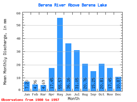
| Statistic | Jan | Feb | Mar | Apr | May | Jun | Jul | Aug | Sep | Oct | Nov | Dec | Annual |
|---|---|---|---|---|---|---|---|---|---|---|---|---|---|
| Mean | 7.20 | 5.00 | 4.69 | 17.45 | 55.56 | 36.16 | 31.05 | 20.76 | 15.25 | 20.81 | 17.45 | 10.87 | 241.20 |
| Standard Deviation | 2.01 | 1.24 | 1.08 | 14.63 | 29.98 | 19.01 | 21.25 | 16.77 | 8.99 | 11.35 | 9.78 | 4.32 | 75.43 |
| Min | 3.06 | 2.44 | 2.44 | 5.16 | 15.00 | 9.54 | 9.86 | 4.81 | 4.20 | 4.00 | 4.79 | 3.86 | 106.98 |
| Max | 11.73 | 6.86 | 6.64 | 57.45 | 107.96 | 72.83 | 81.79 | 62.63 | 37.86 | 43.14 | 48.40 | 23.32 | 429.93 |
| Coefficient of Variation | 0.28 | 0.25 | 0.23 | 0.84 | 0.54 | 0.53 | 0.68 | 0.81 | 0.59 | 0.55 | 0.56 | 0.40 | 0.31 |
 Return to R-Arctic Net Home Page