|
|
|||||||||||||||||
| Point ID: 4451 | Downloads | Plots | Site Data | Code: 05QD025 |
|
|
|||||||||||||||||
| Download | |
|---|---|
| Site Descriptor Information | Site Time Series Data |
| Link to all available data | |
| View: | Time Series | All |
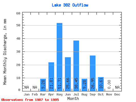
| Units: | m3/s |
| Statistic | Jan | Feb | Mar | Apr | May | Jun | Jul | Aug | Sep | Oct | Nov | Dec | Annual |
|---|---|---|---|---|---|---|---|---|---|---|---|---|---|
| Mean | 9.28 | 22.38 | 52.15 | 25.18 | 38.78 | 9.45 | 26.38 | 10.61 | 0.00 | ||||
| Standard Deviation | 20.77 | 46.54 | 21.24 | 34.58 | 12.92 | 35.73 | 15.76 | ||||||
| Min | 9.28 | 0.00 | 0.00 | 5.13 | 0.00 | 0.00 | 0.00 | 0.00 | 0.00 | ||||
| Max | 9.28 | 64.16 | 131.25 | 69.29 | 103.41 | 37.12 | 87.25 | 41.10 | 0.00 | ||||
| Coefficient of Variation | 0.93 | 0.89 | 0.84 | 0.89 | 1.37 | 1.35 | 1.49 |
 Return to R-Arctic Net Home Page