|
|
|||||||||||||||||
| Point ID: 4443 | Downloads | Plots | Site Data | Code: 05QD013 |
|
|
|||||||||||||||||
| Download | |
|---|---|
| Site Descriptor Information | Site Time Series Data |
| Link to all available data | |
| View: | Time Series | All |
| Units: | m3/s |
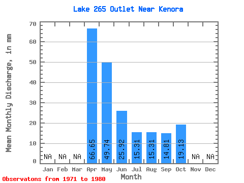
| Statistic | Jan | Feb | Mar | Apr | May | Jun | Jul | Aug | Sep | Oct | Nov | Dec | Annual |
|---|---|---|---|---|---|---|---|---|---|---|---|---|---|
| Mean | 66.24 | 48.88 | 25.92 | 14.03 | 14.88 | 15.22 | 20.40 | ||||||
| Standard Deviation | 38.05 | 39.15 | 22.68 | 12.10 | 22.34 | 12.75 | 19.51 | ||||||
| Min | 3.70 | 3.83 | 0.00 | 0.00 | 0.00 | 3.70 | 0.00 | ||||||
| Max | 107.38 | 107.12 | 70.35 | 34.43 | 61.21 | 37.03 | 65.04 | ||||||
| Coefficient of Variation | 0.57 | 0.80 | 0.88 | 0.86 | 1.50 | 0.84 | 0.96 |
 Return to R-Arctic Net Home Page