|
|
|||||||||||||||||
| Point ID: 4427 | Downloads | Plots | Site Data | Code: 05QA001 |
|
|
|||||||||||||||||
| Download | |
|---|---|
| Site Descriptor Information | Site Time Series Data |
| Link to all available data | |
| View: | Time Series | All |
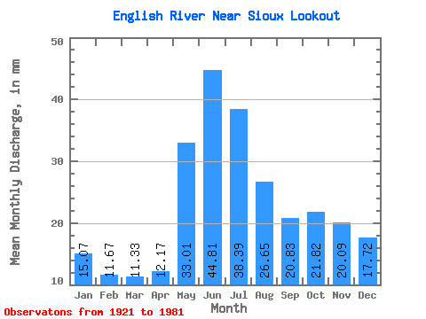
| Units: | m3/s |
| Statistic | Jan | Feb | Mar | Apr | May | Jun | Jul | Aug | Sep | Oct | Nov | Dec | Annual |
|---|---|---|---|---|---|---|---|---|---|---|---|---|---|
| Mean | 15.07 | 11.77 | 11.33 | 12.17 | 33.00 | 44.81 | 38.39 | 26.64 | 20.82 | 21.82 | 20.09 | 17.72 | 272.75 |
| Standard Deviation | 5.89 | 3.76 | 3.18 | 3.95 | 14.78 | 22.91 | 17.91 | 11.50 | 10.55 | 16.23 | 13.96 | 9.62 | 92.22 |
| Min | 3.12 | 3.07 | 3.87 | 5.26 | 8.46 | 13.78 | 10.87 | 8.80 | 6.66 | 4.39 | 3.25 | 3.16 | 96.12 |
| Max | 34.10 | 20.54 | 17.36 | 27.79 | 81.11 | 118.22 | 99.61 | 52.98 | 56.31 | 110.01 | 75.15 | 58.57 | 498.43 |
| Coefficient of Variation | 0.39 | 0.32 | 0.28 | 0.33 | 0.45 | 0.51 | 0.47 | 0.43 | 0.51 | 0.74 | 0.69 | 0.54 | 0.34 |
 Return to R-Arctic Net Home Page