|
|
|||||||||||||||||
| Point ID: 4410 | Downloads | Plots | Site Data | Code: 05PD023 |
|
|
|||||||||||||||||
| Download | |
|---|---|
| Site Descriptor Information | Site Time Series Data |
| Link to all available data | |
| View: | Time Series | All |
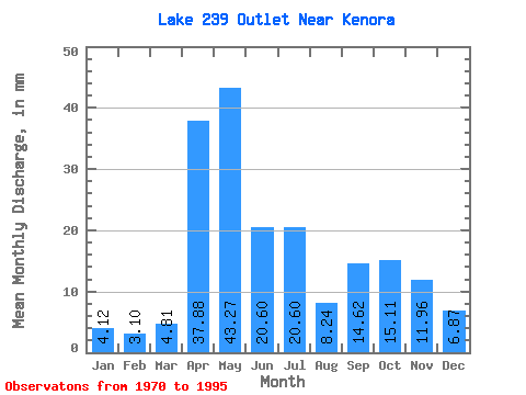
| Units: | m3/s |
| Statistic | Jan | Feb | Mar | Apr | May | Jun | Jul | Aug | Sep | Oct | Nov | Dec | Annual |
|---|---|---|---|---|---|---|---|---|---|---|---|---|---|
| Mean | 4.35 | 3.02 | 4.75 | 37.97 | 43.00 | 20.66 | 20.49 | 8.10 | 14.29 | 15.34 | 12.11 | 7.18 | 192.37 |
| Standard Deviation | 4.08 | 3.00 | 5.50 | 20.31 | 29.57 | 15.23 | 15.93 | 11.78 | 17.98 | 18.10 | 14.14 | 7.66 | 89.67 |
| Min | 0.00 | 0.00 | 0.00 | 0.67 | 5.49 | 1.33 | 0.69 | 0.00 | 0.00 | 0.00 | 0.00 | 0.00 | 59.34 |
| Max | 10.99 | 10.01 | 19.91 | 77.09 | 119.48 | 55.83 | 63.86 | 39.14 | 61.15 | 53.56 | 47.19 | 21.29 | 376.97 |
| Coefficient of Variation | 0.94 | 0.99 | 1.16 | 0.54 | 0.69 | 0.74 | 0.78 | 1.46 | 1.26 | 1.18 | 1.17 | 1.07 | 0.47 |
 Return to R-Arctic Net Home Page