|
|
|||||||||||||||||
| Point ID: 4403 | Downloads | Plots | Site Data | Code: 05PC019 |
|
|
|||||||||||||||||
| Download | |
|---|---|
| Site Descriptor Information | Site Time Series Data |
| Link to all available data | |
| View: | Time Series | All |
| Units: | m3/s |
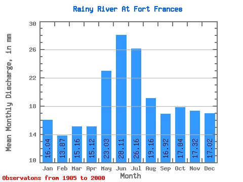
| Statistic | Jan | Feb | Mar | Apr | May | Jun | Jul | Aug | Sep | Oct | Nov | Dec | Annual |
|---|---|---|---|---|---|---|---|---|---|---|---|---|---|
| Mean | 16.04 | 13.99 | 15.16 | 15.12 | 23.02 | 28.11 | 26.15 | 19.16 | 16.92 | 17.84 | 17.32 | 17.02 | 225.53 |
| Standard Deviation | 5.86 | 4.66 | 4.87 | 6.27 | 15.45 | 19.77 | 15.55 | 10.76 | 9.04 | 11.57 | 10.67 | 8.50 | 78.92 |
| Min | 4.53 | 4.27 | 4.53 | 4.69 | 1.10 | 3.77 | 4.36 | 5.05 | 4.73 | 4.99 | 4.39 | 4.59 | 81.65 |
| Max | 33.44 | 27.62 | 25.53 | 38.14 | 67.78 | 88.64 | 92.97 | 71.46 | 51.57 | 77.70 | 58.89 | 51.90 | 500.04 |
| Coefficient of Variation | 0.36 | 0.33 | 0.32 | 0.41 | 0.67 | 0.70 | 0.59 | 0.56 | 0.53 | 0.65 | 0.62 | 0.50 | 0.35 |
 Return to R-Arctic Net Home Page