|
|
|||||||||||||||||
| Point ID: 4402 | Downloads | Plots | Site Data | Code: 05PC018 |
|
|
|||||||||||||||||
| Download | |
|---|---|
| Site Descriptor Information | Site Time Series Data |
| Link to all available data | |
| View: | Time Series | All |
| Units: | m3/s |
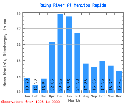
| Statistic | Jan | Feb | Mar | Apr | May | Jun | Jul | Aug | Sep | Oct | Nov | Dec | Annual |
|---|---|---|---|---|---|---|---|---|---|---|---|---|---|
| Mean | 13.79 | 12.00 | 13.54 | 22.65 | 29.55 | 28.95 | 24.98 | 17.25 | 16.36 | 17.95 | 16.77 | 15.41 | 228.70 |
| Standard Deviation | 4.82 | 3.53 | 3.85 | 9.36 | 16.05 | 16.65 | 13.23 | 9.36 | 8.79 | 11.30 | 10.09 | 7.50 | 70.19 |
| Min | 4.38 | 4.31 | 4.42 | 6.40 | 6.19 | 5.37 | 5.26 | 5.17 | 5.47 | 7.15 | 5.58 | 4.82 | 82.49 |
| Max | 27.85 | 23.72 | 25.13 | 55.76 | 80.02 | 72.29 | 72.55 | 50.89 | 44.77 | 64.02 | 54.73 | 41.98 | 431.07 |
| Coefficient of Variation | 0.35 | 0.29 | 0.28 | 0.41 | 0.54 | 0.57 | 0.53 | 0.54 | 0.54 | 0.63 | 0.60 | 0.49 | 0.31 |
 Return to R-Arctic Net Home Page