|
|
|||||||||||||||||
| Point ID: 4397 | Downloads | Plots | Site Data | Code: 05PB022 |
|
|
|||||||||||||||||
| Download | |
|---|---|
| Site Descriptor Information | Site Time Series Data |
| Link to all available data | |
| View: | Time Series | All |
| Units: | m3/s |
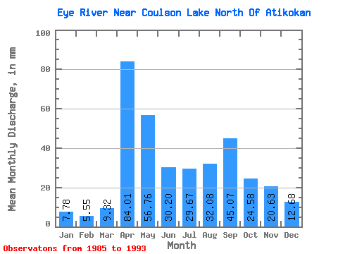
| Statistic | Jan | Feb | Mar | Apr | May | Jun | Jul | Aug | Sep | Oct | Nov | Dec | Annual |
|---|---|---|---|---|---|---|---|---|---|---|---|---|---|
| Mean | 7.80 | 5.63 | 9.29 | 83.99 | 56.75 | 30.17 | 29.65 | 32.04 | 45.04 | 24.61 | 20.67 | 12.71 | 358.34 |
| Standard Deviation | 1.49 | 1.53 | 6.44 | 34.05 | 19.70 | 22.40 | 27.65 | 33.92 | 46.61 | 20.48 | 10.31 | 2.57 | 125.35 |
| Min | 4.99 | 2.45 | 2.50 | 24.81 | 29.09 | 9.39 | 4.13 | 0.58 | 2.32 | 13.54 | 9.76 | 8.93 | 232.73 |
| Max | 9.41 | 8.14 | 24.58 | 143.12 | 85.65 | 77.04 | 95.35 | 89.01 | 124.53 | 78.26 | 45.54 | 18.34 | 615.02 |
| Coefficient of Variation | 0.19 | 0.27 | 0.69 | 0.41 | 0.35 | 0.74 | 0.93 | 1.06 | 1.03 | 0.83 | 0.50 | 0.20 | 0.35 |
 Return to R-Arctic Net Home Page