|
|
|||||||||||||||||
| Point ID: 4396 | Downloads | Plots | Site Data | Code: 05PB021 |
|
|
|||||||||||||||||
| Download | |
|---|---|
| Site Descriptor Information | Site Time Series Data |
| Link to all available data | |
| View: | Time Series | All |
| Units: | m3/s |
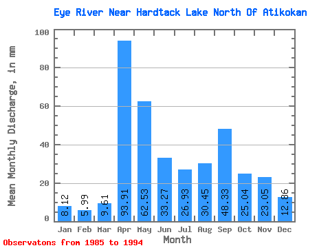
| Statistic | Jan | Feb | Mar | Apr | May | Jun | Jul | Aug | Sep | Oct | Nov | Dec | Annual |
|---|---|---|---|---|---|---|---|---|---|---|---|---|---|
| Mean | 8.17 | 6.09 | 9.61 | 93.94 | 62.56 | 33.32 | 26.88 | 30.42 | 48.32 | 25.01 | 23.02 | 12.80 | 380.37 |
| Standard Deviation | 2.45 | 2.63 | 7.21 | 39.84 | 24.11 | 32.85 | 23.88 | 31.34 | 46.70 | 15.52 | 13.66 | 3.35 | 124.35 |
| Min | 5.14 | 3.08 | 3.52 | 21.48 | 28.28 | 7.73 | 4.06 | 2.17 | 1.70 | 10.15 | 8.91 | 8.66 | 240.14 |
| Max | 12.45 | 11.71 | 25.58 | 155.86 | 103.66 | 105.83 | 89.04 | 93.78 | 138.83 | 65.22 | 52.00 | 19.08 | 665.01 |
| Coefficient of Variation | 0.30 | 0.43 | 0.75 | 0.42 | 0.39 | 0.99 | 0.89 | 1.03 | 0.97 | 0.62 | 0.59 | 0.26 | 0.33 |
 Return to R-Arctic Net Home Page