|
|
|||||||||||||||||
| Point ID: 4387 | Downloads | Plots | Site Data | Code: 05PB001 |
|
|
|||||||||||||||||
| Download | |
|---|---|
| Site Descriptor Information | Site Time Series Data |
| Link to all available data | |
| View: | Time Series | All |
| Units: | m3/s |
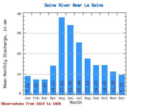
| Statistic | Jan | Feb | Mar | Apr | May | Jun | Jul | Aug | Sep | Oct | Nov | Dec | Annual |
|---|---|---|---|---|---|---|---|---|---|---|---|---|---|
| Mean | 9.06 | 7.40 | 7.40 | 14.07 | 37.60 | 33.90 | 25.48 | 17.62 | 14.47 | 14.45 | 11.28 | 9.73 | 187.62 |
| Standard Deviation | 1.90 | 1.99 | 2.20 | 6.51 | 24.61 | 18.17 | 9.74 | 6.03 | 4.95 | 4.99 | 3.94 | 2.64 | 30.38 |
| Min | 5.96 | 4.63 | 3.82 | 5.90 | 14.91 | 20.42 | 14.82 | 10.71 | 8.49 | 8.17 | 5.05 | 4.76 | 153.54 |
| Max | 11.96 | 10.18 | 10.44 | 22.93 | 90.96 | 75.53 | 41.37 | 28.95 | 23.11 | 22.07 | 15.51 | 12.47 | 229.22 |
| Coefficient of Variation | 0.21 | 0.27 | 0.30 | 0.46 | 0.65 | 0.54 | 0.38 | 0.34 | 0.34 | 0.34 | 0.35 | 0.27 | 0.16 |
 Return to R-Arctic Net Home Page