|
|
|||||||||||||||||
| Point ID: 4385 | Downloads | Plots | Site Data | Code: 05PA006 |
|
|
|||||||||||||||||
| Download | |
|---|---|
| Site Descriptor Information | Site Time Series Data |
| Link to all available data | |
| View: | Time Series | All |
| Units: | m3/s |
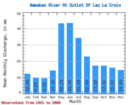
| Statistic | Jan | Feb | Mar | Apr | May | Jun | Jul | Aug | Sep | Oct | Nov | Dec | Annual |
|---|---|---|---|---|---|---|---|---|---|---|---|---|---|
| Mean | 12.34 | 9.77 | 9.52 | 14.16 | 43.18 | 43.42 | 34.34 | 22.89 | 17.33 | 17.31 | 15.97 | 14.60 | 255.72 |
| Standard Deviation | 6.01 | 3.98 | 3.32 | 7.17 | 21.07 | 19.76 | 15.52 | 10.79 | 11.30 | 12.67 | 11.58 | 9.09 | 76.50 |
| Min | 3.10 | 2.77 | 3.02 | 3.37 | 5.10 | 8.09 | 7.13 | 6.36 | 4.24 | 4.22 | 3.42 | 3.22 | 96.92 |
| Max | 25.78 | 17.70 | 16.97 | 49.71 | 95.53 | 121.09 | 90.13 | 63.35 | 71.96 | 80.34 | 58.03 | 40.77 | 493.91 |
| Coefficient of Variation | 0.49 | 0.41 | 0.35 | 0.51 | 0.49 | 0.46 | 0.45 | 0.47 | 0.65 | 0.73 | 0.72 | 0.62 | 0.30 |
 Return to R-Arctic Net Home Page