|
|
|||||||||||||||||
| Point ID: 4383 | Downloads | Plots | Site Data | Code: 04MF001 |
|
|
|||||||||||||||||
| Download | |
|---|---|
| Site Descriptor Information | Site Time Series Data |
| Link to all available data | |
| View: | Time Series | All |
| Units: | m3/s |
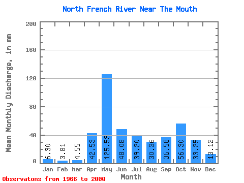
| Statistic | Jan | Feb | Mar | Apr | May | Jun | Jul | Aug | Sep | Oct | Nov | Dec | Annual |
|---|---|---|---|---|---|---|---|---|---|---|---|---|---|
| Mean | 6.30 | 3.85 | 4.55 | 42.53 | 125.51 | 48.08 | 39.19 | 30.35 | 36.58 | 56.29 | 33.25 | 13.12 | 436.83 |
| Standard Deviation | 2.54 | 1.58 | 4.62 | 34.49 | 49.62 | 20.25 | 21.43 | 24.99 | 24.68 | 29.57 | 14.80 | 6.50 | 93.75 |
| Min | 1.45 | 1.51 | 1.63 | 2.05 | 33.55 | 17.73 | 7.14 | 6.21 | 6.01 | 9.46 | 11.37 | 3.08 | 234.13 |
| Max | 12.91 | 8.77 | 23.93 | 136.97 | 240.94 | 111.36 | 88.60 | 103.03 | 118.73 | 169.58 | 73.72 | 30.87 | 648.80 |
| Coefficient of Variation | 0.40 | 0.41 | 1.01 | 0.81 | 0.40 | 0.42 | 0.55 | 0.82 | 0.68 | 0.53 | 0.45 | 0.50 | 0.21 |
 Return to R-Arctic Net Home Page