|
|
|||||||||||||||||
| Point ID: 4382 | Downloads | Plots | Site Data | Code: 04ME004 |
|
|
|||||||||||||||||
| Download | |
|---|---|
| Site Descriptor Information | Site Time Series Data |
| Link to all available data | |
| View: | Time Series | All |
| Units: | m3/s |
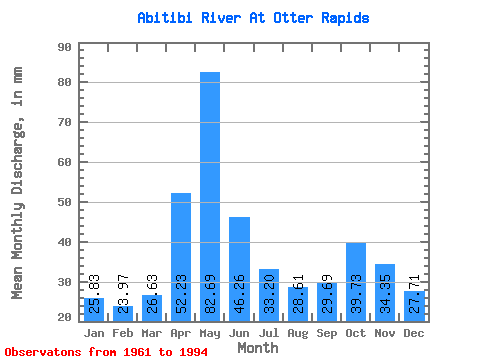
| Statistic | Jan | Feb | Mar | Apr | May | Jun | Jul | Aug | Sep | Oct | Nov | Dec | Annual |
|---|---|---|---|---|---|---|---|---|---|---|---|---|---|
| Mean | 25.82 | 24.18 | 26.63 | 52.23 | 82.68 | 46.26 | 33.20 | 28.60 | 29.69 | 39.73 | 34.35 | 27.71 | 450.03 |
| Standard Deviation | 4.65 | 4.78 | 4.94 | 19.73 | 29.69 | 19.08 | 11.77 | 7.56 | 7.78 | 14.85 | 12.01 | 5.78 | 74.51 |
| Min | 15.56 | 14.39 | 18.08 | 22.27 | 28.50 | 24.81 | 20.37 | 18.43 | 17.72 | 19.23 | 20.60 | 18.65 | 296.83 |
| Max | 37.19 | 42.44 | 42.92 | 97.59 | 152.21 | 100.91 | 70.73 | 50.58 | 44.20 | 76.22 | 82.63 | 46.24 | 638.28 |
| Coefficient of Variation | 0.18 | 0.20 | 0.18 | 0.38 | 0.36 | 0.41 | 0.35 | 0.26 | 0.26 | 0.37 | 0.35 | 0.21 | 0.17 |
 Return to R-Arctic Net Home Page