|
|
|||||||||||||||||
| Point ID: 4364 | Downloads | Plots | Site Data | Code: 04LD001 |
|
|
|||||||||||||||||
| Download | |
|---|---|
| Site Descriptor Information | Site Time Series Data |
| Link to all available data | |
| View: | Time Series | All |
| Units: | m3/s |
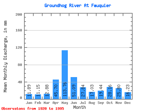
| Statistic | Jan | Feb | Mar | Apr | May | Jun | Jul | Aug | Sep | Oct | Nov | Dec | Annual |
|---|---|---|---|---|---|---|---|---|---|---|---|---|---|
| Mean | 11.89 | 11.25 | 12.87 | 45.70 | 113.74 | 51.09 | 27.84 | 17.03 | 19.44 | 28.16 | 25.80 | 16.23 | 381.15 |
| Standard Deviation | 3.58 | 3.41 | 4.30 | 27.35 | 41.28 | 23.31 | 14.80 | 7.79 | 13.70 | 19.99 | 13.50 | 7.54 | 82.90 |
| Min | 3.06 | 3.01 | 4.19 | 6.08 | 25.66 | 18.56 | 7.54 | 4.32 | 4.42 | 4.23 | 3.83 | 4.43 | 229.10 |
| Max | 20.39 | 19.11 | 24.53 | 120.02 | 261.05 | 132.87 | 67.96 | 40.28 | 74.06 | 111.17 | 66.87 | 44.11 | 721.15 |
| Coefficient of Variation | 0.30 | 0.30 | 0.33 | 0.60 | 0.36 | 0.46 | 0.53 | 0.46 | 0.70 | 0.71 | 0.52 | 0.46 | 0.22 |
 Return to R-Arctic Net Home Page