|
|
|||||||||||||||||
| Point ID: 4362 | Downloads | Plots | Site Data | Code: 04LB001 |
|
|
|||||||||||||||||
| Download | |
|---|---|
| Site Descriptor Information | Site Time Series Data |
| Link to all available data | |
| View: | Time Series | All |
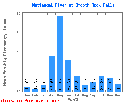
| Units: | m3/s |
| Statistic | Jan | Feb | Mar | Apr | May | Jun | Jul | Aug | Sep | Oct | Nov | Dec | Annual |
|---|---|---|---|---|---|---|---|---|---|---|---|---|---|
| Mean | 14.68 | 13.44 | 16.62 | 46.68 | 86.06 | 41.57 | 25.83 | 17.26 | 19.90 | 26.32 | 24.00 | 17.77 | 350.13 |
| Standard Deviation | 2.69 | 2.77 | 4.79 | 23.20 | 36.97 | 20.07 | 12.54 | 5.66 | 12.35 | 16.36 | 10.73 | 5.89 | 77.78 |
| Min | 7.93 | 7.34 | 7.85 | 10.73 | 17.09 | 15.19 | 8.11 | 6.21 | 5.68 | 8.46 | 8.50 | 7.82 | 206.17 |
| Max | 22.87 | 22.23 | 33.48 | 114.31 | 207.54 | 120.79 | 64.54 | 34.81 | 80.35 | 102.83 | 57.28 | 43.92 | 718.28 |
| Coefficient of Variation | 0.18 | 0.21 | 0.29 | 0.50 | 0.43 | 0.48 | 0.48 | 0.33 | 0.62 | 0.62 | 0.45 | 0.33 | 0.22 |
 Return to R-Arctic Net Home Page