|
|
|||||||||||||||||
| Point ID: 4361 | Downloads | Plots | Site Data | Code: 04LA002 |
|
|
|||||||||||||||||
| Download | |
|---|---|
| Site Descriptor Information | Site Time Series Data |
| Link to all available data | |
| View: | Time Series | All |
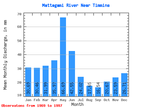
| Units: | m3/s |
| Statistic | Jan | Feb | Mar | Apr | May | Jun | Jul | Aug | Sep | Oct | Nov | Dec | Annual |
|---|---|---|---|---|---|---|---|---|---|---|---|---|---|
| Mean | 30.68 | 30.72 | 31.98 | 35.97 | 66.68 | 42.55 | 24.01 | 17.65 | 16.54 | 20.66 | 23.59 | 26.71 | 368.22 |
| Standard Deviation | 4.38 | 5.43 | 5.79 | 16.20 | 28.54 | 19.04 | 10.23 | 6.18 | 5.79 | 8.87 | 10.33 | 8.12 | 69.58 |
| Min | 23.11 | 17.35 | 23.06 | 14.36 | 12.38 | 9.36 | 10.93 | 8.85 | 8.38 | 8.89 | 11.04 | 11.36 | 226.45 |
| Max | 38.33 | 40.96 | 46.65 | 77.20 | 142.60 | 85.15 | 50.27 | 35.38 | 36.73 | 46.70 | 54.27 | 47.76 | 514.84 |
| Coefficient of Variation | 0.14 | 0.18 | 0.18 | 0.45 | 0.43 | 0.45 | 0.43 | 0.35 | 0.35 | 0.43 | 0.44 | 0.30 | 0.19 |
 Return to R-Arctic Net Home Page