|
|
|||||||||||||||||
| Point ID: 4357 | Downloads | Plots | Site Data | Code: 04JG001 |
|
|
|||||||||||||||||
| Download | |
|---|---|
| Site Descriptor Information | Site Time Series Data |
| Link to all available data | |
| View: | Time Series | All |
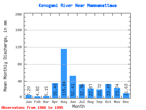
| Units: | m3/s |
| Statistic | Jan | Feb | Mar | Apr | May | Jun | Jul | Aug | Sep | Oct | Nov | Dec | Annual |
|---|---|---|---|---|---|---|---|---|---|---|---|---|---|
| Mean | 7.20 | 4.86 | 5.15 | 35.40 | 115.83 | 52.41 | 32.95 | 22.87 | 20.73 | 33.48 | 23.73 | 11.62 | 363.11 |
| Standard Deviation | 2.36 | 1.23 | 1.41 | 25.11 | 38.41 | 18.58 | 17.48 | 18.29 | 15.71 | 16.56 | 9.43 | 3.92 | 74.72 |
| Min | 3.17 | 2.79 | 2.96 | 5.44 | 30.56 | 23.25 | 6.37 | 3.70 | 3.00 | 4.86 | 5.07 | 3.65 | 242.62 |
| Max | 14.82 | 7.70 | 8.79 | 94.28 | 221.80 | 101.90 | 73.49 | 85.76 | 73.01 | 68.18 | 38.78 | 18.70 | 550.52 |
| Coefficient of Variation | 0.33 | 0.25 | 0.27 | 0.71 | 0.33 | 0.35 | 0.53 | 0.80 | 0.76 | 0.49 | 0.40 | 0.34 | 0.21 |
 Return to R-Arctic Net Home Page