|
|
|||||||||||||||||
| Point ID: 4355 | Downloads | Plots | Site Data | Code: 04JD005 |
|
|
|||||||||||||||||
| Download | |
|---|---|
| Site Descriptor Information | Site Time Series Data |
| Link to all available data | |
| View: | Time Series | All |
| Units: | m3/s |
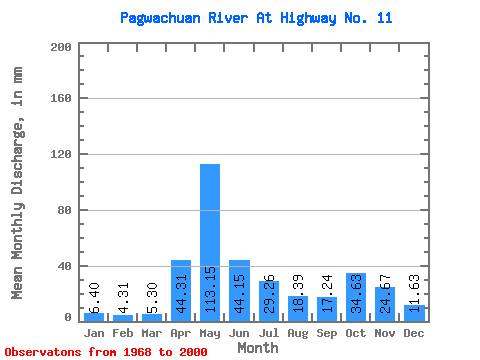
| Statistic | Jan | Feb | Mar | Apr | May | Jun | Jul | Aug | Sep | Oct | Nov | Dec | Annual |
|---|---|---|---|---|---|---|---|---|---|---|---|---|---|
| Mean | 6.40 | 4.35 | 5.30 | 44.31 | 113.14 | 44.15 | 29.25 | 18.39 | 17.24 | 34.62 | 24.67 | 11.63 | 351.77 |
| Standard Deviation | 2.19 | 1.36 | 4.34 | 32.13 | 47.78 | 18.52 | 17.57 | 17.90 | 16.08 | 24.86 | 13.23 | 5.30 | 80.69 |
| Min | 2.48 | 2.05 | 2.17 | 5.88 | 21.34 | 11.71 | 4.47 | 2.32 | 1.39 | 3.06 | 3.81 | 2.81 | 183.47 |
| Max | 10.95 | 6.59 | 27.84 | 129.60 | 237.31 | 91.23 | 64.56 | 70.66 | 70.83 | 116.27 | 56.84 | 24.00 | 523.93 |
| Coefficient of Variation | 0.34 | 0.31 | 0.82 | 0.72 | 0.42 | 0.42 | 0.60 | 0.97 | 0.93 | 0.72 | 0.54 | 0.46 | 0.23 |
 Return to R-Arctic Net Home Page