|
|
|||||||||||||||||
| Point ID: 4352 | Downloads | Plots | Site Data | Code: 04JC003 |
|
|
|||||||||||||||||
| Download | |
|---|---|
| Site Descriptor Information | Site Time Series Data |
| Link to all available data | |
| View: | Time Series | All |
| Units: | m3/s |
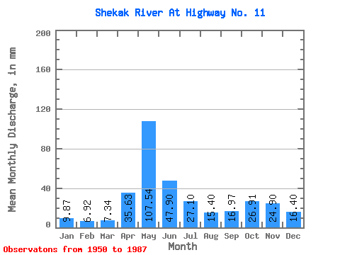
| Statistic | Jan | Feb | Mar | Apr | May | Jun | Jul | Aug | Sep | Oct | Nov | Dec | Annual |
|---|---|---|---|---|---|---|---|---|---|---|---|---|---|
| Mean | 9.87 | 6.98 | 7.34 | 35.63 | 107.52 | 47.90 | 27.10 | 15.40 | 16.97 | 26.91 | 24.90 | 16.39 | 344.80 |
| Standard Deviation | 2.15 | 1.59 | 1.93 | 19.93 | 37.43 | 17.51 | 14.16 | 9.63 | 12.65 | 16.28 | 12.29 | 5.25 | 60.88 |
| Min | 6.37 | 4.57 | 4.62 | 8.27 | 31.01 | 18.36 | 6.67 | 2.78 | 2.55 | 4.38 | 7.26 | 7.03 | 222.01 |
| Max | 14.49 | 11.12 | 11.97 | 86.66 | 182.33 | 85.09 | 62.84 | 35.57 | 59.95 | 67.81 | 54.60 | 31.01 | 473.88 |
| Coefficient of Variation | 0.22 | 0.23 | 0.26 | 0.56 | 0.35 | 0.37 | 0.52 | 0.62 | 0.74 | 0.60 | 0.49 | 0.32 | 0.18 |
 Return to R-Arctic Net Home Page