|
|
|||||||||||||||||
| Point ID: 4351 | Downloads | Plots | Site Data | Code: 04JC002 |
|
|
|||||||||||||||||
| Download | |
|---|---|
| Site Descriptor Information | Site Time Series Data |
| Link to all available data | |
| View: | Time Series | All |
| Units: | m3/s |
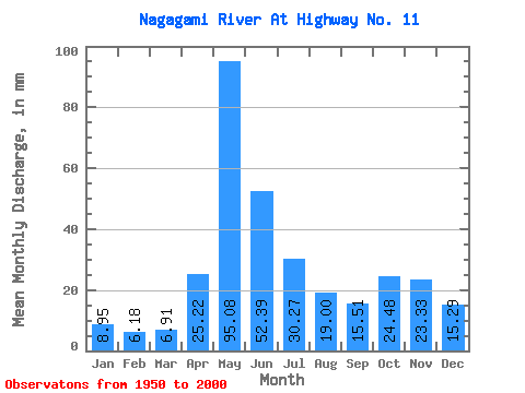
| Statistic | Jan | Feb | Mar | Apr | May | Jun | Jul | Aug | Sep | Oct | Nov | Dec | Annual |
|---|---|---|---|---|---|---|---|---|---|---|---|---|---|
| Mean | 8.95 | 6.24 | 6.91 | 25.22 | 95.06 | 52.40 | 30.26 | 19.00 | 15.51 | 24.48 | 23.33 | 15.29 | 321.40 |
| Standard Deviation | 2.70 | 1.73 | 2.31 | 13.06 | 29.08 | 17.95 | 14.16 | 12.22 | 11.32 | 17.87 | 12.98 | 6.41 | 65.02 |
| Min | 3.22 | 2.88 | 3.52 | 7.47 | 31.34 | 19.36 | 7.92 | 3.87 | 1.59 | 3.23 | 4.27 | 3.50 | 188.69 |
| Max | 14.67 | 10.23 | 17.22 | 56.25 | 161.12 | 88.62 | 70.67 | 61.01 | 53.56 | 78.78 | 54.64 | 27.11 | 480.68 |
| Coefficient of Variation | 0.30 | 0.28 | 0.33 | 0.52 | 0.31 | 0.34 | 0.47 | 0.64 | 0.73 | 0.73 | 0.56 | 0.42 | 0.20 |
 Return to R-Arctic Net Home Page