|
|
|||||||||||||||||
| Point ID: 4344 | Downloads | Plots | Site Data | Code: 04GD001 |
|
|
|||||||||||||||||
| Download | |
|---|---|
| Site Descriptor Information | Site Time Series Data |
| Link to all available data | |
| View: | Time Series | All |
| Units: | m3/s |
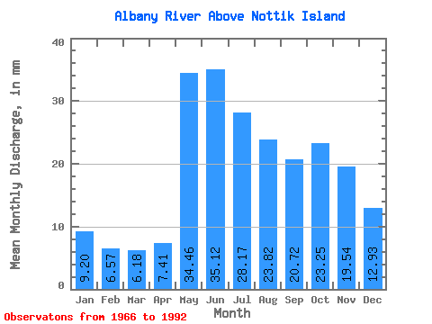
| Statistic | Jan | Feb | Mar | Apr | May | Jun | Jul | Aug | Sep | Oct | Nov | Dec | Annual |
|---|---|---|---|---|---|---|---|---|---|---|---|---|---|
| Mean | 9.20 | 6.62 | 6.17 | 7.41 | 34.45 | 35.12 | 28.17 | 23.82 | 20.72 | 23.24 | 19.54 | 12.93 | 227.33 |
| Standard Deviation | 5.38 | 3.88 | 3.32 | 3.32 | 12.10 | 18.20 | 13.27 | 13.07 | 12.99 | 13.96 | 11.95 | 7.41 | 88.09 |
| Min | 3.51 | 2.40 | 2.40 | 3.09 | 16.37 | 16.64 | 11.57 | 6.76 | 3.58 | 2.51 | 2.77 | 3.92 | 114.97 |
| Max | 23.31 | 16.79 | 16.45 | 17.36 | 64.97 | 104.00 | 67.61 | 57.28 | 45.04 | 51.25 | 47.76 | 32.15 | 414.71 |
| Coefficient of Variation | 0.58 | 0.59 | 0.54 | 0.45 | 0.35 | 0.52 | 0.47 | 0.55 | 0.63 | 0.60 | 0.61 | 0.57 | 0.39 |
 Return to R-Arctic Net Home Page