|
|
|||||||||||||||||
| Point ID: 4343 | Downloads | Plots | Site Data | Code: 04GC002 |
|
|
|||||||||||||||||
| Download | |
|---|---|
| Site Descriptor Information | Site Time Series Data |
| Link to all available data | |
| View: | Time Series | All |
| Units: | m3/s |
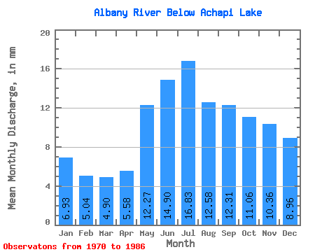
| Statistic | Jan | Feb | Mar | Apr | May | Jun | Jul | Aug | Sep | Oct | Nov | Dec | Annual |
|---|---|---|---|---|---|---|---|---|---|---|---|---|---|
| Mean | 6.93 | 5.08 | 4.90 | 5.58 | 12.27 | 14.90 | 16.83 | 12.58 | 12.31 | 11.06 | 10.36 | 8.96 | 117.97 |
| Standard Deviation | 7.13 | 5.43 | 4.97 | 3.00 | 4.77 | 19.29 | 20.02 | 11.15 | 12.30 | 11.22 | 10.84 | 10.01 | 85.92 |
| Min | 1.23 | 1.01 | 1.20 | 2.38 | 6.55 | 5.80 | 4.34 | 3.07 | 2.10 | 2.05 | 2.05 | 1.60 | 40.83 |
| Max | 24.97 | 21.41 | 19.06 | 14.39 | 25.63 | 82.53 | 71.30 | 38.61 | 45.64 | 49.78 | 45.32 | 37.62 | 332.49 |
| Coefficient of Variation | 1.03 | 1.07 | 1.01 | 0.54 | 0.39 | 1.29 | 1.19 | 0.89 | 1.00 | 1.01 | 1.05 | 1.12 | 0.73 |
 Return to R-Arctic Net Home Page