|
|
|||||||||||||||||
| Point ID: 4339 | Downloads | Plots | Site Data | Code: 04GA003 |
|
|
|||||||||||||||||
| Download | |
|---|---|
| Site Descriptor Information | Site Time Series Data |
| Link to all available data | |
| View: | Time Series | All |
| Units: | m3/s |
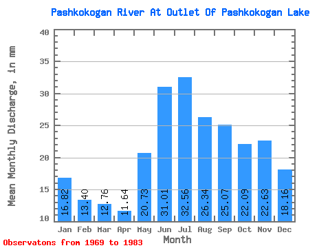
| Statistic | Jan | Feb | Mar | Apr | May | Jun | Jul | Aug | Sep | Oct | Nov | Dec | Annual |
|---|---|---|---|---|---|---|---|---|---|---|---|---|---|
| Mean | 16.82 | 13.52 | 12.76 | 11.64 | 20.72 | 31.00 | 32.56 | 26.33 | 25.07 | 22.09 | 22.63 | 18.15 | 227.47 |
| Standard Deviation | 8.90 | 6.05 | 4.80 | 4.26 | 7.44 | 14.22 | 13.99 | 13.43 | 14.95 | 12.87 | 11.38 | 11.45 | 96.61 |
| Min | 4.98 | 4.22 | 4.89 | 5.10 | 12.73 | 14.53 | 13.09 | 7.52 | 6.04 | 5.12 | 5.09 | 5.38 | 119.02 |
| Max | 31.70 | 23.63 | 18.97 | 17.09 | 32.54 | 49.98 | 57.76 | 46.35 | 48.12 | 36.87 | 35.68 | 36.51 | 346.38 |
| Coefficient of Variation | 0.53 | 0.45 | 0.38 | 0.37 | 0.36 | 0.46 | 0.43 | 0.51 | 0.60 | 0.58 | 0.50 | 0.63 | 0.42 |
 Return to R-Arctic Net Home Page