|
|
|||||||||||||||||
| Point ID: 4334 | Downloads | Plots | Site Data | Code: 04FA002 |
|
|
|||||||||||||||||
| Download | |
|---|---|
| Site Descriptor Information | Site Time Series Data |
| Link to all available data | |
| View: | Time Series | All |
| Units: | m3/s |
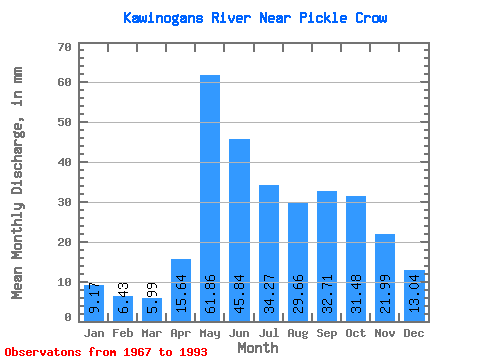
| Statistic | Jan | Feb | Mar | Apr | May | Jun | Jul | Aug | Sep | Oct | Nov | Dec | Annual |
|---|---|---|---|---|---|---|---|---|---|---|---|---|---|
| Mean | 9.16 | 6.49 | 5.99 | 15.64 | 61.85 | 45.84 | 34.27 | 29.66 | 32.71 | 31.47 | 21.99 | 13.04 | 312.62 |
| Standard Deviation | 2.73 | 1.65 | 1.41 | 9.06 | 33.03 | 29.24 | 17.62 | 20.09 | 23.96 | 20.25 | 14.61 | 5.38 | 129.82 |
| Min | 3.95 | 3.01 | 3.18 | 4.66 | 9.58 | 7.44 | 9.72 | 5.41 | 4.06 | 4.66 | 6.08 | 5.03 | 129.16 |
| Max | 14.52 | 9.51 | 8.94 | 33.83 | 140.51 | 136.84 | 70.43 | 68.34 | 87.86 | 83.47 | 62.78 | 25.04 | 541.35 |
| Coefficient of Variation | 0.30 | 0.25 | 0.24 | 0.58 | 0.53 | 0.64 | 0.51 | 0.68 | 0.73 | 0.64 | 0.66 | 0.41 | 0.41 |
 Return to R-Arctic Net Home Page