|
|
|||||||||||||||||
| Point ID: 4321 | Downloads | Plots | Site Data | Code: 04CB001 |
|
|
|||||||||||||||||
| Download | |
|---|---|
| Site Descriptor Information | Site Time Series Data |
| Link to all available data | |
| View: | Time Series | All |
| Units: | m3/s |
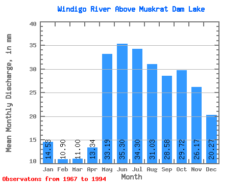
| Statistic | Jan | Feb | Mar | Apr | May | Jun | Jul | Aug | Sep | Oct | Nov | Dec | Annual |
|---|---|---|---|---|---|---|---|---|---|---|---|---|---|
| Mean | 14.53 | 10.99 | 11.00 | 13.34 | 33.18 | 35.30 | 34.29 | 31.02 | 28.58 | 29.71 | 26.17 | 20.27 | 288.87 |
| Standard Deviation | 4.88 | 3.29 | 2.97 | 5.07 | 12.26 | 13.97 | 15.73 | 15.83 | 16.36 | 16.17 | 12.20 | 8.54 | 99.60 |
| Min | 7.96 | 6.17 | 6.47 | 7.58 | 10.56 | 9.50 | 12.89 | 12.42 | 9.79 | 13.27 | 11.93 | 10.39 | 153.95 |
| Max | 25.54 | 16.81 | 16.66 | 29.76 | 56.04 | 71.04 | 77.61 | 70.42 | 71.52 | 80.34 | 65.52 | 46.87 | 486.60 |
| Coefficient of Variation | 0.34 | 0.30 | 0.27 | 0.38 | 0.37 | 0.40 | 0.46 | 0.51 | 0.57 | 0.54 | 0.47 | 0.42 | 0.34 |
 Return to R-Arctic Net Home Page