|
|
|||||||||||||||||
| Point ID: 4319 | Downloads | Plots | Site Data | Code: 04CA003 |
|
|
|||||||||||||||||
| Download | |
|---|---|
| Site Descriptor Information | Site Time Series Data |
| Link to all available data | |
| View: | Time Series | All |
| Units: | m3/s |
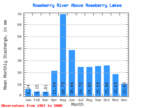
| Statistic | Jan | Feb | Mar | Apr | May | Jun | Jul | Aug | Sep | Oct | Nov | Dec | Annual |
|---|---|---|---|---|---|---|---|---|---|---|---|---|---|
| Mean | 6.24 | 4.19 | 3.81 | 21.54 | 68.78 | 38.66 | 24.72 | 24.81 | 25.58 | 25.84 | 18.63 | 10.63 | 270.89 |
| Standard Deviation | 1.88 | 1.40 | 1.44 | 16.88 | 27.32 | 27.05 | 20.88 | 27.93 | 26.41 | 18.11 | 9.07 | 3.59 | 101.37 |
| Min | 2.74 | 2.57 | 2.32 | 4.10 | 29.55 | 5.36 | 4.02 | 2.19 | 1.53 | 0.96 | 1.88 | 2.45 | 130.62 |
| Max | 12.42 | 9.62 | 9.52 | 51.92 | 136.28 | 92.54 | 85.66 | 90.85 | 118.92 | 86.09 | 36.35 | 16.92 | 511.31 |
| Coefficient of Variation | 0.30 | 0.33 | 0.38 | 0.78 | 0.40 | 0.70 | 0.84 | 1.13 | 1.03 | 0.70 | 0.49 | 0.34 | 0.37 |
 Return to R-Arctic Net Home Page