|
|
|||||||||||||||||
| Point ID: 427 | Downloads | Plots | Site Data | Code: 05CJ006 |
|
|
|||||||||||||||||
| Download | |
|---|---|
| Site Descriptor Information | Site Time Series Data |
| Link to all available data | |
| View: | Time Series | All |
| Units: | m3/s |
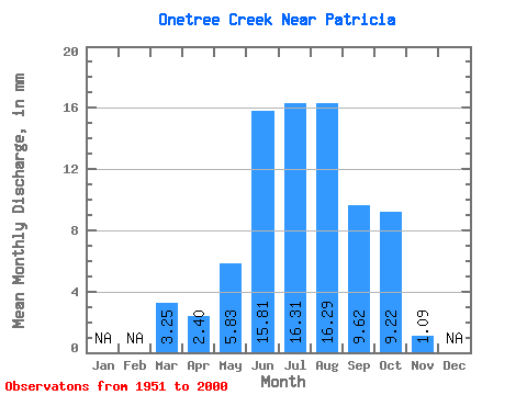
| Statistic | Jan | Feb | Mar | Apr | May | Jun | Jul | Aug | Sep | Oct | Nov | Dec | Annual |
|---|---|---|---|---|---|---|---|---|---|---|---|---|---|
| Mean | 3.25 | 2.40 | 5.83 | 15.81 | 16.31 | 16.29 | 9.62 | 9.22 | 1.09 | ||||
| Standard Deviation | 3.33 | 2.53 | 4.00 | 7.92 | 4.75 | 3.91 | 3.28 | 2.63 | 0.56 | ||||
| Min | 0.27 | 0.35 | 0.79 | 8.00 | 9.83 | 9.99 | 4.21 | 4.00 | 0.44 | ||||
| Max | 16.52 | 12.44 | 21.54 | 62.19 | 39.68 | 30.77 | 15.52 | 15.28 | 1.76 | ||||
| Coefficient of Variation | 1.03 | 1.06 | 0.69 | 0.50 | 0.29 | 0.24 | 0.34 | 0.28 | 0.51 |
 Return to R-Arctic Net Home Page