|
|
|||||||||||||||||
| Point ID: 402 | Downloads | Plots | Site Data | Code: 05CE019 |
|
|
|||||||||||||||||
| Download | |
|---|---|
| Site Descriptor Information | Site Time Series Data |
| Link to all available data | |
| View: | Time Series | All |
| Units: | m3/s |
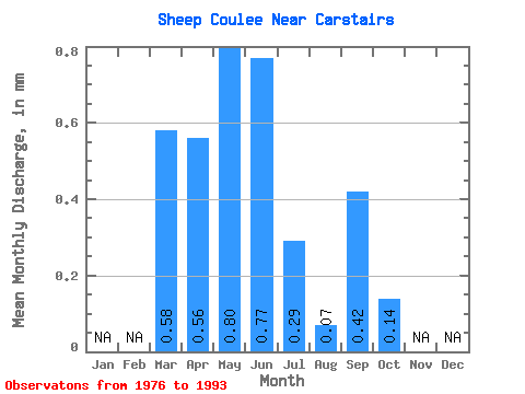
| Statistic | Jan | Feb | Mar | Apr | May | Jun | Jul | Aug | Sep | Oct | Nov | Dec | Annual |
|---|---|---|---|---|---|---|---|---|---|---|---|---|---|
| Mean | 0.53 | 0.56 | 0.79 | 0.72 | 0.28 | 0.09 | 0.38 | 0.14 | |||||
| Standard Deviation | 0.64 | 0.62 | 1.13 | 1.34 | 0.38 | 0.10 | 0.95 | 0.38 | |||||
| Min | 0.00 | 0.00 | 0.00 | 0.00 | 0.00 | 0.00 | 0.00 | 0.00 | |||||
| Max | 1.82 | 1.83 | 4.41 | 5.42 | 1.19 | 0.28 | 3.59 | 1.61 | |||||
| Coefficient of Variation | 1.20 | 1.10 | 1.43 | 1.86 | 1.38 | 1.09 | 2.47 | 2.78 |
 Return to R-Arctic Net Home Page