|
|
|||||||||||||||||
| Point ID: 400 | Downloads | Plots | Site Data | Code: 05CE016 |
|
|
|||||||||||||||||
| Download | |
|---|---|
| Site Descriptor Information | Site Time Series Data |
| Link to all available data | |
| View: | Time Series | All |
| Units: | m3/s |
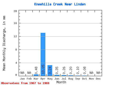
| Statistic | Jan | Feb | Mar | Apr | May | Jun | Jul | Aug | Sep | Oct | Nov | Dec | Annual |
|---|---|---|---|---|---|---|---|---|---|---|---|---|---|
| Mean | 0.42 | 11.47 | 2.85 | 0.31 | 0.22 | 0.17 | 0.09 | 0.07 | |||||
| Standard Deviation | 0.73 | 13.48 | 4.13 | 0.25 | 0.16 | 0.23 | 0.09 | 0.02 | |||||
| Min | 0.00 | 0.20 | 0.07 | 0.15 | 0.11 | 0.01 | 0.02 | 0.05 | |||||
| Max | 1.27 | 26.40 | 7.59 | 0.59 | 0.34 | 0.34 | 0.15 | 0.08 | |||||
| Coefficient of Variation | 1.73 | 1.18 | 1.45 | 0.81 | 0.73 | 1.31 | 1.08 | 0.27 |
 Return to R-Arctic Net Home Page