|
|
|||||||||||||||||
| Point ID: 394 | Downloads | Plots | Site Data | Code: 05CE009 |
|
|
|||||||||||||||||
| Download | |
|---|---|
| Site Descriptor Information | Site Time Series Data |
| Link to all available data | |
| View: | Time Series | All |
| Units: | m3/s |
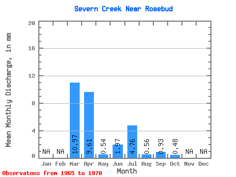
| Statistic | Jan | Feb | Mar | Apr | May | Jun | Jul | Aug | Sep | Oct | Nov | Dec | Annual |
|---|---|---|---|---|---|---|---|---|---|---|---|---|---|
| Mean | 9.31 | 8.15 | 0.46 | 1.67 | 4.03 | 0.48 | 0.79 | 0.40 | |||||
| Standard Deviation | 13.08 | 10.51 | 0.76 | 1.51 | 8.91 | 0.96 | 1.22 | 0.49 | |||||
| Min | 0.66 | 0.15 | 0.05 | 0.13 | 0.00 | 0.00 | 0.00 | 0.00 | |||||
| Max | 31.70 | 23.46 | 1.81 | 4.15 | 22.20 | 2.42 | 3.15 | 1.19 | |||||
| Coefficient of Variation | 1.41 | 1.29 | 1.66 | 0.91 | 2.21 | 2.00 | 1.55 | 1.22 |
 Return to R-Arctic Net Home Page