|
|
|||||||||||||||||
| Point ID: 388 | Downloads | Plots | Site Data | Code: 05CE003 |
|
|
|||||||||||||||||
| Download | |
|---|---|
| Site Descriptor Information | Site Time Series Data |
| Link to all available data | |
| View: | Time Series | All |
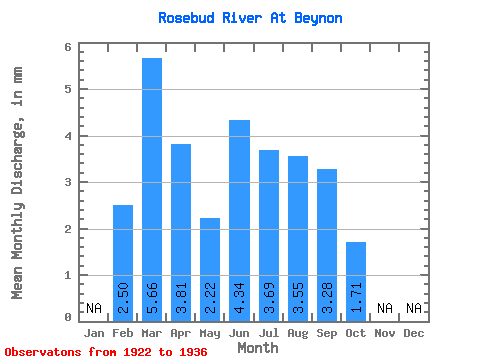
| Units: | m3/s |
| Statistic | Jan | Feb | Mar | Apr | May | Jun | Jul | Aug | Sep | Oct | Nov | Dec | Annual |
|---|---|---|---|---|---|---|---|---|---|---|---|---|---|
| Mean | 1.73 | 3.89 | 2.61 | 1.52 | 2.98 | 2.53 | 2.44 | 2.25 | 1.17 | ||||
| Standard Deviation | 3.96 | 3.25 | 0.35 | 1.59 | 1.20 | 1.20 | 0.86 | 0.81 | |||||
| Min | 1.73 | 0.15 | 0.35 | 0.92 | 1.03 | 1.59 | 1.26 | 1.23 | 0.40 | ||||
| Max | 1.73 | 9.46 | 10.52 | 2.25 | 6.56 | 5.60 | 5.11 | 3.60 | 3.42 | ||||
| Coefficient of Variation | 1.02 | 1.25 | 0.23 | 0.53 | 0.47 | 0.49 | 0.38 | 0.69 |
 Return to R-Arctic Net Home Page