|
|
|||||||||||||||||
| Point ID: 386 | Downloads | Plots | Site Data | Code: 05CE001 |
|
|
|||||||||||||||||
| Download | |
|---|---|
| Site Descriptor Information | Site Time Series Data |
| Link to all available data | |
| View: | Time Series | All |
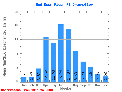
| Units: | m3/s |
| Statistic | Jan | Feb | Mar | Apr | May | Jun | Jul | Aug | Sep | Oct | Nov | Dec | Annual |
|---|---|---|---|---|---|---|---|---|---|---|---|---|---|
| Mean | 1.23 | 1.15 | 3.11 | 10.28 | 8.98 | 13.22 | 12.11 | 7.03 | 4.71 | 3.39 | 1.84 | 1.32 | 67.79 |
| Standard Deviation | 0.52 | 0.49 | 2.47 | 7.52 | 7.32 | 9.29 | 8.48 | 4.34 | 3.98 | 2.06 | 0.78 | 0.57 | 29.55 |
| Min | 0.30 | 0.31 | 0.50 | 2.56 | 2.11 | 3.20 | 1.86 | 2.81 | 2.03 | 1.53 | 0.84 | 0.24 | 30.50 |
| Max | 2.15 | 2.05 | 11.01 | 32.19 | 43.62 | 42.33 | 39.09 | 29.59 | 29.27 | 13.28 | 4.95 | 2.68 | 185.65 |
| Coefficient of Variation | 0.42 | 0.42 | 0.79 | 0.73 | 0.81 | 0.70 | 0.70 | 0.62 | 0.85 | 0.61 | 0.42 | 0.43 | 0.44 |
 Return to R-Arctic Net Home Page