|
|
|||||||||||||||||
| Point ID: 383 | Downloads | Plots | Site Data | Code: 05CD006 |
|
|
|||||||||||||||||
| Download | |
|---|---|
| Site Descriptor Information | Site Time Series Data |
| Link to all available data | |
| View: | Time Series | All |
| Units: | m3/s |
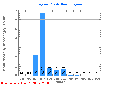
| Statistic | Jan | Feb | Mar | Apr | May | Jun | Jul | Aug | Sep | Oct | Nov | Dec | Annual |
|---|---|---|---|---|---|---|---|---|---|---|---|---|---|
| Mean | 2.28 | 6.70 | 0.80 | 0.68 | 0.70 | 0.13 | 0.07 | 0.03 | |||||
| Standard Deviation | 2.93 | 8.80 | 0.93 | 1.91 | 1.35 | 0.21 | 0.16 | 0.07 | |||||
| Min | 0.00 | 0.02 | 0.00 | 0.00 | 0.00 | 0.00 | 0.00 | 0.00 | |||||
| Max | 10.66 | 31.23 | 3.95 | 9.10 | 6.10 | 0.73 | 0.77 | 0.27 | |||||
| Coefficient of Variation | 1.29 | 1.31 | 1.15 | 2.83 | 1.92 | 1.62 | 2.46 | 2.47 |
 Return to R-Arctic Net Home Page