|
|
|||||||||||||||||
| Point ID: 371 | Downloads | Plots | Site Data | Code: 05CB007 |
|
|
|||||||||||||||||
| Download | |
|---|---|
| Site Descriptor Information | Site Time Series Data |
| Link to all available data | |
| View: | Time Series | All |
| Units: | m3/s |
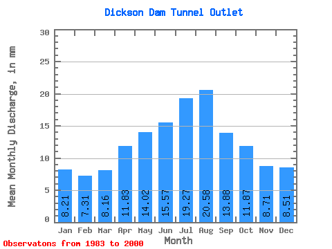
| Statistic | Jan | Feb | Mar | Apr | May | Jun | Jul | Aug | Sep | Oct | Nov | Dec | Annual |
|---|---|---|---|---|---|---|---|---|---|---|---|---|---|
| Mean | 8.15 | 7.32 | 8.10 | 11.75 | 13.92 | 15.46 | 19.13 | 20.43 | 13.78 | 11.78 | 8.65 | 8.44 | 141.98 |
| Standard Deviation | 0.51 | 0.48 | 0.48 | 4.52 | 5.79 | 8.32 | 9.25 | 6.06 | 4.78 | 5.17 | 1.24 | 0.72 | 23.23 |
| Min | 7.36 | 6.80 | 7.51 | 7.68 | 5.45 | 5.37 | 0.00 | 12.72 | 7.50 | 7.36 | 7.17 | 7.60 | 112.39 |
| Max | 9.42 | 8.76 | 9.52 | 22.54 | 22.19 | 32.17 | 28.69 | 31.04 | 24.86 | 30.13 | 12.27 | 10.19 | 176.77 |
| Coefficient of Variation | 0.06 | 0.07 | 0.06 | 0.38 | 0.42 | 0.54 | 0.48 | 0.30 | 0.35 | 0.44 | 0.14 | 0.09 | 0.16 |
 Return to R-Arctic Net Home Page