|
|
|||||||||||||||||
| Point ID: 370 | Downloads | Plots | Site Data | Code: 05CB005 |
|
|
|||||||||||||||||
| Download | |
|---|---|
| Site Descriptor Information | Site Time Series Data |
| Link to all available data | |
| View: | Time Series | All |
| Units: | m3/s |
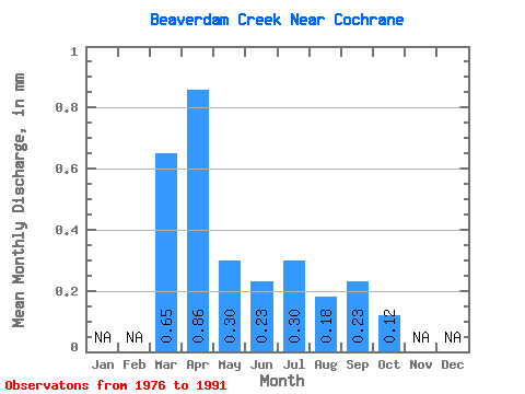
| Statistic | Jan | Feb | Mar | Apr | May | Jun | Jul | Aug | Sep | Oct | Nov | Dec | Annual |
|---|---|---|---|---|---|---|---|---|---|---|---|---|---|
| Mean | 0.65 | 0.83 | 0.29 | 0.21 | 0.29 | 0.19 | 0.24 | 0.15 | |||||
| Standard Deviation | 0.93 | 1.46 | 0.31 | 0.20 | 0.55 | 0.39 | 0.58 | 0.36 | |||||
| Min | 0.00 | 0.00 | 0.00 | 0.00 | 0.00 | 0.00 | 0.00 | 0.00 | |||||
| Max | 2.90 | 5.61 | 1.18 | 0.69 | 1.83 | 1.36 | 2.17 | 1.30 | |||||
| Coefficient of Variation | 1.44 | 1.76 | 1.07 | 0.95 | 1.90 | 2.00 | 2.46 | 2.48 |
 Return to R-Arctic Net Home Page