|
|
|||||||||||||||||
| Point ID: 3696 | Downloads | Plots | Site Data | Code: 10VC001 |
|
|
|||||||||||||||||
| Download | |
|---|---|
| Site Descriptor Information | Site Time Series Data |
| Link to all available data | |
| View: | Time Series | All |
| Units: | m3/s |
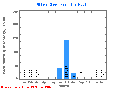
| Statistic | Jan | Feb | Mar | Apr | May | Jun | Jul | Aug | Sep | Oct | Nov | Dec | Annual |
|---|---|---|---|---|---|---|---|---|---|---|---|---|---|
| Mean | 0.00 | 0.00 | 0.00 | 0.00 | 0.00 | 32.82 | 115.11 | 18.66 | 0.13 | 0.00 | 0.00 | 0.00 | 158.78 |
| Standard Deviation | 0.00 | 0.00 | 0.00 | 0.00 | 0.00 | 43.12 | 42.57 | 8.31 | 0.09 | 0.00 | 0.00 | 0.00 | 24.81 |
| Min | 0.00 | 0.00 | 0.00 | 0.00 | 0.00 | 0.00 | 31.08 | 7.35 | 0.06 | 0.00 | 0.00 | 0.00 | 130.60 |
| Max | 0.00 | 0.00 | 0.00 | 0.00 | 0.00 | 90.84 | 163.79 | 34.43 | 0.27 | 0.00 | 0.00 | 0.00 | 177.33 |
| Coefficient of Variation | 1.31 | 0.37 | 0.45 | 0.65 | 0.16 |
 Return to R-Arctic Net Home Page